The first introduction of Indonesia's population to Islam
In the year 30 Hijri or 651 AD, only about 20 years ago of the death of the Prophet Muhammad, the Caliph Uthman ibn Affan RA send a delegation to China to introduce Daula Muslims, who have long standing. In a journey that took four years, the delegates turned out to Uthman had stopped at the Islands of the archipelago. Several years later, exactly the year AD 674, Umayyad Dynasty has established trade base on the west coast of Sumatra. This is the first introduction of Indonesia's population to Islam. Since then the sailors and Muslim merchants continued to arrive, century after century. They buy local produce from the land of green this while preaching.
First Islamic kingdom in Indonesia
Gradually, the indigenous population began to embrace Islam, although not yet on a large scale. Aceh, the westernmost region of the Islands archipelago, is the first to accept Islam. Even in Aceh, first Islamic kingdom in Indonesia was established, namely Pasai. News from Marcopolo mentioned that at the time of sojourn in Pasai year 692 AH / 1292 AD, were many Arabs who spread Islam. Similarly, news of Ibn Battuthah, nomadic Muslims from the Maghreb., Which when dropped in Aceh in 746 AH / 1345 AD wrote that in Aceh have been scattered schools of Shafi'i. The oldest relic of the Muslims who are found in Indonesia located in Gresik, East Java. Form of Islamic tomb complex, in which one of them is the tomb of a Muslim woman named Fatima bint Maimun. Numbers written on his tomb in 475 AH / 1082 AD, ie at the time of the Kingdom of Singasari. It is estimated that these tombs are not from the natives, but the tomb of Arab traders.
Islam came to Southeast Asia by way of peace, not with a sword, not to seize political power
Until the 8th century H / 14 AD, there is no indigenous population embraced Islam en masse. New in the 9th century H / 14 AD, the indigenous population embraced Islam en masse. The historians argue that Islam entered the archipelago population on a large scale in the century was due at that time the Muslims already have a significant political force. That is marked by the establishment of several Islamic kingdoms such as the Kingdom of patterned Aceh Darussalam, Malacca, Demak, Cirebon, and Ternate. The rulers of these kingdoms of mixed blood, descendants of the kings of the indigenous pre-Islamic and Arab immigrants. The rapid Islamization of the 14th century and 15 M, among others, are also caused by the decline of power and influence of the kingdoms of the Hindu / Buddhist in the archipelago such as Majapahit, Srivijaya and Sundanese. Thomas Arnold in The Preaching of Islam says that the arrival of Islam is not as conquerors as well as the Portuguese and Spanish. Islam came to Southeast Asia by way of peace, not with a sword, not to seize political power. Islam entered the archipelago in a way that really show it as RAHMATAN LIL'ALAMIN.
With the native population into Islam Nusantara and the establishment of Islamic governments in different parts of the archipelago, the trade with the Muslims from the center of the Islamic world became increasingly tight. The Arabs who migrated to the archipelago is also growing. The largest of which is derived from Hadramaut, Yemen. In the chronicle of Hadramawt, migration is even said to be the largest in the history of Hadramaut. But after the Christian European nations and the greedy master coming area-by area in the archipelago, the relationship with the center of the Islamic world as if disconnected. Especially in the 17th and 18th centuries AD. The reason, other than because the Muslim archipelago occupied by the resistance against colonialism, as well as various regulations created by the colonialist. Every time the invaders - notably the Netherlands - subjugate the Islamic kingdom in the archipelago, they would thrust the royal ban treaty whose contents are related to trade with the outside world except through them. So terputuslah Nusantara relations with the Islamic ummah of Muslims from other nations who had established hundreds of years. The colonialist desire to alienate Muslims archipelago with its roots, also visible from the assimilation policies that make them among the Arabs with the natives.
The arrival of the colonialists
Since the early arrival of the Europeans at the end of the 15th century AD to the fertile island is prosperous, is already seen their greedy nature to master. Moreover, they found the fact that the population of these islands have embraced Islam, the religion of their enemies, so that the spirit of the Crusades was always carry around every time they beat a region. In their fight against Islam in collaboration with indigenous kingdoms that still adhered to Hindu / Buddhist. One example, to decide cruise lines of the Muslims, then having seized Malacca in 1511, the Portuguese cooperation with the Kingdom of Sunda Pajajaran to build a base in Sunda Kelapa. But the purpose of this Portuguese failed miserably after the combined forces of Islam from the north coast of Java along hand in hand to demolish them in 1527 AD Of this historic battle led by an Arab-blooded son of Aceh Gujarat, namely Al-Pasai Fadhilah Khan, better known by his title, Fathahillah. Before becoming an important man in the three Islamic kingdom of Java, namely Demak, Cirebon and Banten, Fathahillah had studied in Mecca. Even the participate defend Mecca of the Ottoman Turkish invasion.
The arrival of the colonialists on the one side has awakened the spirit of jihad of the Muslims archipelago, but on the other side make the deepening of belief in Islam is uneven. Only the pesantren (Islamic schools) who studied Islam, and even then usually limited to the Shafi'i school. While the majority Muslims, mixing faith with pre-Islamic traditions. Aristocratic circles close to the Dutch even have affected the European lifestyle. Conditions like this still happen at least until now. Apart from this, scholars Archipelago are the people who persevere against colonialism. Although many of them come from the congregation, but it is often among the congregation rose up against the invaders. And although in the end it was crushed any resistance with tactics devious, but history has recorded millions of martyrs who died in the archipelago a number of battles against the Dutch. Since the resistance of Islamic kingdoms in the 16th and 17th centuries such as Malacca (Malaysia), Sulu (Philippines), Pasai, Banten, Sunda Kelapa, Makassar, Ternate, until the resistance of the scholars in the 18th century such as the War of Cirebon (Bagus Rangin), Java War (Diponegoro), Padri War (Imam Bonjol), and the war in Aceh (Teuku Umar).
Source:
http://www.ummah.net/
Saturday, 25 September 2010
Tuesday, 21 September 2010
Lontong Balap: Special and Original's Food From Surabaya
 The ingredients
Typical original Surabaya's food in east java, which is cooked from the rice cake, sprouts, fried tofu, Lento (made of soybean), soy sauce, fried onion and chili sauce.
Lento is made from rice peanuts/Tholo with flour, afterwards it is added with galingale, the spring onion, rough-skinned citrus fruit and adequate salt. It is formed round resembled the croquette.
Lontong Balap is full of sprouts. Lontong Balap is not served well without Kerang Satay (Shellfish satay).
Shellfish satay, is made from the shellfish that is boiled and then it is served like satay, but without being roasted. Lontong Balap will be more delicious to eat if being added with hot soy sauce and chili sauce.
The history
Long ago, "lontong balap" sold by using the pole. Vegetable sprouts are included in large pot soil. Borne soil pot front and back. Because of the heavy pot, the seller walks very fast. Imagine if carry a certain weight and fast way in hurry. It was quick as the race (balap) was impressed. Perhaps that way it is called Lontong Balap . Seller was in hurry like racing (balapan).
Source:
http://www.surabaya.go.id/eng/culture.php?page=lontong_balap
Thursday, 16 September 2010
Naskah Wangsakerta, the controversial manuscript about history of Javaland Kingdoms
 Naskah (Manuscript) Wangsakerta is a term that refers to a set of scripts that were prepared by Prince Wangsakerta personally or by the "Panitia Wangsakerta". According to the contents of Pustaka Rajya Rajya i Bhumi Nusantara parwa (part) V sarga (vol / script) 5 in the form of a list of libraries, library Sultanate of Cirebon collect at least 1703 the title of the manuscript, which is 1213 of which form works Wangsakerta Prince and his team.
This controversial manuscript is now stored at the Museum of History Sunda "Sri Baduga" in Bandung.
Controversy
Wangsakerta manuscript discovery in the early 1970s, besides causing excitement and admiration will completeness, to many it was a cause of doubt and suspicion, even the scholars and historians suspect that this manuscript real but fake. Among the reasons doubt this manuscript, namely:
- Too historical, it is not common as contemporary texts (chronicle, ballad, legend, saga);
- Fitting the content of the manuscript with the works of Western scholars (JG de Casparis, NJ Krom, Eugene Dubois, etc..), So there is a suspicion that the manuscript was prepared with reference to the work of these experts (not made of the 17th century);
- Physical state of the manuscript (paper / Daluang, ink, character building) shows a script that made reference to a rough copy and writing, not like the old script in general.
The texts produced by Panitia Wangsakerta
In the preface each manuscript Wangsakerta kept informed about the process of making of these manuscripts. The committee - led by Prince - Wangsakerta is intended to meet the demand / mandate of his father, Panembahan Girilaya, Prince Wangsakerta preparing the manuscript for the story of the kingdoms in the archipelago. The committee was established to conduct a gotrasawala (symposium / seminar) between the experts (sajarah) of the entire archipelago, the results are compiled and written into the texts now known as Manuscript Wangsakerta. Gotrasawala took place in 1599 Saka (1677 AD), while the preparation of papers to spend up to 21 years (completed in 1620 Saka, 1698 M).
[Edit] Works Committee Wangsakerta
The texts produced by the Committee Wangsakerta can be classified into several headings:
* Reader Rajyarajya i Bhumi Nusantara
* Reader Pararatwan
* Reader Carita Parahyangan i Bhumi Kulwan Java
* Reader Nagarakretabhumi
* Reader Samastabhuwana
* Copies of the books of law Majapahit
* Collection of Carita, Katha, and itihasa
* Library of kings and king of a small village
* Copies of some Java script Kuna
* Mahabharata
* Collection kathosana
* Copies of inscriptions
* Copies of letters of friendship treaty
* The text of the story traders
* Manuscript in various other regional languages and foreign languages
* Widyapustaka Collection (various sciences)
* Islamic Library
* Sarwakrama kings Salakanagara
* Sarwakrama kings Tarumanagara
* Sarwakrama kings and Pajajaran Galuh
* Sarwakrama kings Galuh
* Sarwakrama kings of Central and East Java
* The kings and princes Majapahit
* The kings and princes of Bali
* The kings and princes and Kadiri Janggala
* The kings and princes of Srivijaya
* Kings of Bali, Kadiri, and Janggala
* Copies of manuscripts Prapanca work
Wednesday, 15 September 2010
Kutai Martadipura, the first kingdom in Kalimantan (Borneo)
Kutai Martadipura is patterned Hindu kingdom in the archipelago which has the oldest historical evidence. The kingdom was located in Muara Kaman, East Kalimantan, precisely in the Mahakam river upstream. Kutai name is taken. Kutai name given by experts to take from place names found inscriptions indicating the existence of the kingdom. There are no inscriptions that clearly mentions the name of this kingdom, and indeed very little information can be obtained.
 The yupa ( inscription )
The information is obtained from Yupa / inscription in the sacrifice that comes from the 4th century. There are seven pieces yupa which became the main source for experts in interpreting the history of the Kingdom of Kutai. From one of these yupa known that the king who ruled the kingdom of Kutai time was Mulawarman. His name is recorded in yupa because of his generosity menyedekahkan 20,000 cows to the Brahmins.
King Mulawarman
Mulawarman are children of Aswawarman and grandchildren of Kundungga . Name Aswawarman and Mulawarman are very thick with the influence of Sanskrit when viewed from the way of writing. Kundungga is the magnifying of the Kingdom of Campa (Cambodia) which came to Indonesia. Kundungga itself allegedly have not embraced Buddhism.
King Aswawarman
Aswawarman is probably the first king who figured Hindu Kingdom of Kutai. He is also known as the founder of the dynasty of the Kingdom of Kutai Wangsakerta so given the title, which means forming a family. Aswawarman has 3 sons, and one of them is Mulawarman.
Son Aswawarman is Mulawarman. From yupa known that during the reign of Mulawarman, Kingdom of Kutai its moment of glory. Territory covering almost the entire region of East Kalimantan. People Kutai prosperous and affluent life.
Socio-economic life of the Kingdom of Kutai
Judging from the location of the kingdom of Kutai in trade and shipping route between the West and East, the trading activity seems to be the main livelihood. People Kutai has been actively involved in international trade and trade of course they also get to the waters of the East Java Sea and Indonesia to look for merchandise that sold well in the International market. Thus, Kutai has included a stopover area of international trade, namely the Straits of Malacca, Java Sea-Makassar Straits-Kutai - China, or vice versa.
Culture & Beliefs Kingdom of Kutai
Kutai community cultural life is closely related to belief / religious affiliation. Yupa is one of the Kutai culture, which is a stone monument which is the ancestral heritage of Indonesia from the Megalithic era, namely the form of menhirs.
One yupa it mentions a sacred place by the name Waprakeswara (place of worship of Lord Shiva). It can be concluded that the community's religious Kutai is Shiva (Hindu).
 The ended of this kingdom
Kutai kingdom of ends when the King of Kutai named Maharaja Setia Dharma killed in battle at the hands of King aquatic mammal to-13, Aji Prince Panji Mendapa Anum. Keep in mind that this Kutai (Kutai Martadipura) differs from aquatic mammal kingdom whose capital was first located in Kutai Lama (Cape Kute). Kukar is, in the year 1365, mentioned in the Java literature, Negarakertagama . Kutai Kartanegara further into the Islamic empire called the Sultanate of Kutai Kartanegara (Kesultanan Kutai Kartanegara).
Kingdom of Kutaias if it did not appear again by the outside world because of lack of communication with foreign parties, until very little is heard of him.
The name and culture affect
Name of Maharaja Kundungga interpreted by historians as the original name of the Indonesian people who have not been affected by the name of culture India. Meanwhile, son named Asmawarman alleged to have affected the culture of Hindu. This one is based on the fact that the word comes from the language Sangsekerta. Word 'Warman' is typically used to the last names of people or inhabitants of South India.
Tuesday, 14 September 2010
Salakanagara, the first kingdom in Javaland
Salakanagara, based on the Manuscript Wangsakerta - Reader Rajyarajya i Bhumi Nusantara (who prepared a committee with its chairman Prince Wangsakerta) are thought to be the earliest kingdoms in the archipelago).
Name experts and historians who proves that the Tatar Banten have historical values that high, among others, is Hussein Djajadiningrat, Tb. H. Achmad Hasan Mu'arif Ambary, Halwany Michrob and others. Many of their findings has been compiled in the writings, reviews or in books. Not to mention the names like John Miksic, Takashi, Atja, Saleh Danasasmita, Yoseph Iskandar, Claude Guillot, Ayatrohaedi, Vishnu Handoko and others who add insight about Banten became more spacious and open with his works made both in Indonesian and English.
Indian descent
Founder Salakanagara, Dewawarman is an ambassador around, traders as well as immigrants from Pallawa, Bharata (India), who eventually settled for marrying the daughter of the local lords, while the founder is Maharesi Jayasingawarman Tarumanagara, refugees from the region Calankayana, Bharata because the area controlled by another kingdom. While Kutai was established by refugees from Magada, Bharata after the area was also dominated by another kingdom.
Early leaders of the ruling here is Aki Tirem. That said, the city is called Argyre by Ptolemy in the year 150, is located in the Gulf region Pepper Pandeglang. Aki is Tirem, prince or ruler of a local village that eventually became law when the daughter of Sang Aki Dewawarman Luhur Mulya named Goddard Pwahaci Lara was married by Dewawarman. This makes all the followers and forces Dewawarman married local women and did not want to go back to his hometown.
When Aki Tirem died, Dewawarman receive the scepter. Year 130 AD he later founded a kingdom with the name Salakanagara (Silver State) capital is Rajatapura. He became the first king with the title of King Darmalokapala Dewawarman Aji Raksa Gapura Sagara. Several small kingdoms around him into his territory, including the Kingdom Agnynusa (Fire District) located on the island of Krakatoa.
Salakanagara Rajatapura is the capital of up to 362 years into the administrative center of the Kings Dewawarman (from Dewawarman I - VIII). Salakanagara stood just over 232 years, precisely from the year 130 AD until 362 AD. King Dewawarman I own only in power for 38 years and replaced by his son who became King Dewawarman II with the title of King Digwijayakasa Dewawarmanputra. King Dharmawirya recorded as King of kings Salakanagara Dewawarman VIII or last until the year 363, because since it Salakanagara has become a kingdom which is under the authority Tarumanagara founded in 358 AD by the sages that come from Calankayana, India named Jayasinghawarman. In the reign of Dewawarman VIII, the economic situation very well populated, prosperous and safe, while the religious life is very harmonious.
The last period of this kingdom
While Jayasinghawarman founder is daughter of King Dewawarman Tarumanagara VIII. He is himself an Indian sages of Calankayana who fled to the archipelago because the area was attacked and conquered the kingdom of Maharaja Samudragupta Maurya.
In later days after Jayasinghawarman establish Tarumanagara, central government to switch from Rajatapura Tarumanagara. Salakanagara then transformed into the Kingdom of the Region.
The order of the King Salakanagara
130-168 M,

Timeline of kingdoms in West Java/Banten
Name experts and historians who proves that the Tatar Banten have historical values that high, among others, is Hussein Djajadiningrat, Tb. H. Achmad Hasan Mu'arif Ambary, Halwany Michrob and others. Many of their findings has been compiled in the writings, reviews or in books. Not to mention the names like John Miksic, Takashi, Atja, Saleh Danasasmita, Yoseph Iskandar, Claude Guillot, Ayatrohaedi, Vishnu Handoko and others who add insight about Banten became more spacious and open with his works made both in Indonesian and English.
Indian descent
Founder Salakanagara, Dewawarman is an ambassador around, traders as well as immigrants from Pallawa, Bharata (India), who eventually settled for marrying the daughter of the local lords, while the founder is Maharesi Jayasingawarman Tarumanagara, refugees from the region Calankayana, Bharata because the area controlled by another kingdom. While Kutai was established by refugees from Magada, Bharata after the area was also dominated by another kingdom.
Early leaders of the ruling here is Aki Tirem. That said, the city is called Argyre by Ptolemy in the year 150, is located in the Gulf region Pepper Pandeglang. Aki is Tirem, prince or ruler of a local village that eventually became law when the daughter of Sang Aki Dewawarman Luhur Mulya named Goddard Pwahaci Lara was married by Dewawarman. This makes all the followers and forces Dewawarman married local women and did not want to go back to his hometown.
When Aki Tirem died, Dewawarman receive the scepter. Year 130 AD he later founded a kingdom with the name Salakanagara (Silver State) capital is Rajatapura. He became the first king with the title of King Darmalokapala Dewawarman Aji Raksa Gapura Sagara. Several small kingdoms around him into his territory, including the Kingdom Agnynusa (Fire District) located on the island of Krakatoa.
Salakanagara Rajatapura is the capital of up to 362 years into the administrative center of the Kings Dewawarman (from Dewawarman I - VIII). Salakanagara stood just over 232 years, precisely from the year 130 AD until 362 AD. King Dewawarman I own only in power for 38 years and replaced by his son who became King Dewawarman II with the title of King Digwijayakasa Dewawarmanputra. King Dharmawirya recorded as King of kings Salakanagara Dewawarman VIII or last until the year 363, because since it Salakanagara has become a kingdom which is under the authority Tarumanagara founded in 358 AD by the sages that come from Calankayana, India named Jayasinghawarman. In the reign of Dewawarman VIII, the economic situation very well populated, prosperous and safe, while the religious life is very harmonious.
The last period of this kingdom
While Jayasinghawarman founder is daughter of King Dewawarman Tarumanagara VIII. He is himself an Indian sages of Calankayana who fled to the archipelago because the area was attacked and conquered the kingdom of Maharaja Samudragupta Maurya.
In later days after Jayasinghawarman establish Tarumanagara, central government to switch from Rajatapura Tarumanagara. Salakanagara then transformed into the Kingdom of the Region.
The order of the King Salakanagara
130-168 M,
- Real name: DEWAWARMAN I
- Royal name: PRABU DARMALOKAPALA AJI RAKSA GAPURA SEGARA
- Description: Traders from Bharata (India)
- Real name: DEWAWARMAN II
- Royal name: PRABU DIGWIJAYAKASA DEWAWARMANPUTRA
- Description: the oldest son of Dewawarman I
- Real name: DEWAWARMAN III
- Royal name: PRABU SINGASAGARA BIMAYASAWIRYA
- Description: Son of Dewawarman II
- Real Name: DEWAWARMAN IV
- Descripstion: Son in laws of Dewawarman II, King of Ujung Kulon
- Real name: DEWAWARMAN V
- Descripstion: Son in laws of Dewawarman IV
- Real name: MAHISASURAMARDINI WARMANDEWI
- Description: oldest daughter of Dewawarman IV & Dewawarman V's wife, because Dewawarman V die against pirates,
- Real name: DEWAWARMAN VI
- Royal name: SANG MOKTENG SAMUDRA
- Description: the oldest son Dewawarman V
- Real name: DEWAWARMAN VII
- Royal name: PRABU BIMA DIGWIJAYA SATYAGANAPATI
- Description: the oldest son Dewawarman VI
- Real name: SPHATIKARNAWA WARMANDEWI
- Description: the oldest daughter Dewawarman VII
- Real name: DEWAWARMAN VIII
- Royal name: PRABU DARMAWIRYA DEWAWARMAN
- Description: grandson who married Sphatikarnawa Dewawarman VI, the last king Salakanagara

Timeline of kingdoms in West Java/Banten
Sunday, 12 September 2010
Indonesia in simply mentioning
Geoposition
Indonesia is an archipelago in Southeast Asia consisting of 17,000 islands (6,000 inhabited) and straddling the equator. Its neighbor to the north is Malaysia and to the east is Papua New Guinea. The major islands are:
- Sumatra,
- Jawa (Java is the most populous),
- Bali (The island of gods),
- Kalimantan (Indonesia's part of Borneo),
- Sulawesi (Celebes),
- The Nusa Tenggara islands,
- The Maluku (Moluccas) Islands,
- Irian Jaya (West Papua).
Short history
The 17,000 islands that make up Indonesia were home to a diversity of cultures and indigenous beliefs when the islands came under the influence of Hindu priests and traders in the first and second centuries A.D. Muslim traders began in the 13th century, and most of the archipelago had converted to Islam by the 15th century. Portuguese invasion began early in the next century. Then the Dutch colonize this country around 1595. India Company established posts on the island of Java, in an effort to control the spice trade.
The British ever colonize the islands but returned them to the Dutch in 1816. During World War II, Japan take control the islands. After Japan's surrender, Indonesian represented by Sukarno and Hatta, proclaimed Indonesian independence on Aug. 17, 1945.Saturday, 11 September 2010
The meaning of Nusantara/Nuswantara
At the time of Majapahit, "nusantara" is used to name the islands outside Java (between in Sanskrit means the outside, opposite) as opposed to the Jawadwipa (Java). Sumpah Palapa of Gajah Mada in writing "Lamun huwus kalah nuswantara, isun amukti palapa" (If you have lost the islands opposite, then I enjoy the break).
In the 1920s, Ernest Francois Eugene Douwes Dekker (1879-1950), known as Dr. Setiabudi (grandson of the brother Multatuli), introduces a name for Indonesia, which does not contain elements of the word "Indian". The name was no other is Nusantara, a term that has been submerged for centuries. Setiabudi took the name from Pararaton, Majapahit era of ancient manuscripts found in Bali at the end of the 19th century and translated by JLA Brandes and published by Johannes Nicholaas Krom in 1920.
The definition of Nusantara that proposed by Setiabudi much different from the meaning of nusantara in Majapahit era.
By Dr. Setiabudi, the word "nusantara" that connotes ignorance Majapahit era was given a nationalistic sense. By taking the original Malay word between, now, Nusantara has a new meaning of "homeland between the two continents and two oceans", so that Java was included in the definition of a modern country. The term nusantara of Setiabudi is rapidly becoming popular as an alternative use of the name of the Hindia Belanda.
Friday, 10 September 2010
Indonesia is The Lost Atlantis, isn't it ??
 Location hypotheses of Atlantis
These are various proposed real-world settings for the island of Atlantis, (Ἀτλαντὶς νῆσος) a lost civilization mentioned in Plato's dialogues Timaeus and Critias, written about 360 B.C. In these dialogues, a character named Critias claims that an island called Atlantis was swallowed by the sea about 9,200 years previously. This story was passed down to him through his grandfather, Dropides who in turn got it from Solon, the famous Athenian lawmaker who translated it from the Egyptian language. Plato's dialogues locate the island in the Atlantic Pelagos “Atlantic Sea”,[1] "in front of" the Pillars of Hercules (Ηράκλειες Στήλες) and facing a district called modern Gades or Gadira (Gadiron), a location that many modern scholars associate with modern Gibraltar; however various locations have been proposed.
It also figures in the Celtic myths concerning Mererid, the sinful daughter of King Gradlon, whose scabrous conduct led to the sinking of the land of Ys. So, in the Americas (Bochica, etc.) and elsewhere.
![]() If we read the Bible attentively, we note that it also speaks of two creations, exactly as Plato also tells of two different Atlantises (cf. Gen. 1 and 2). Moreover, the Bible also tells of two destructions of the world by the Deluge. These two different narratives are quaintly embroidered on each other in Gen. 6, and comprise the Elohist and the Jahvist accounts of the Flood, which relate two visibly different events.
If we read the Bible attentively, we note that it also speaks of two creations, exactly as Plato also tells of two different Atlantises (cf. Gen. 1 and 2). Moreover, the Bible also tells of two destructions of the world by the Deluge. These two different narratives are quaintly embroidered on each other in Gen. 6, and comprise the Elohist and the Jahvist accounts of the Flood, which relate two visibly different events.
The Bible Is Right After All
The Elusive Sunken Continent Revealed![]() We see, then, that the tradition (or traditions) narrated by Plato exactly coincides with the Biblical lore. Moreover, as we said above, the two traditions also exactly agree with the prehistoric events observed in the geological and the archaeological records. And, when we trace the worldwide legends to their source, we always end up in India and Indonesia, the two Atlantises of legend, no matter where we start from.
We see, then, that the tradition (or traditions) narrated by Plato exactly coincides with the Biblical lore. Moreover, as we said above, the two traditions also exactly agree with the prehistoric events observed in the geological and the archaeological records. And, when we trace the worldwide legends to their source, we always end up in India and Indonesia, the two Atlantises of legend, no matter where we start from.
![]() In truth, continents don t sink. It is the sea that rises, flooding entire continents, as it did in Lemurian Atlantis and, to a great extent, in the Indus Valley, the site of the second Atlantis. Relativists will say that both events sea level rise and continental sinking are one and the same thing, at least from the point of view of the observers. But geologists will hotly debate the issue, and claim, as they have long done, that actual sunken continents are a geological impossibility. It is all a matter of perspective, of relativistic illusion. But the best ancient sources say, for instance that magnificent Hindu saga, the Mahabharata speak of sea level rising rather than of continents sinking.
In truth, continents don t sink. It is the sea that rises, flooding entire continents, as it did in Lemurian Atlantis and, to a great extent, in the Indus Valley, the site of the second Atlantis. Relativists will say that both events sea level rise and continental sinking are one and the same thing, at least from the point of view of the observers. But geologists will hotly debate the issue, and claim, as they have long done, that actual sunken continents are a geological impossibility. It is all a matter of perspective, of relativistic illusion. But the best ancient sources say, for instance that magnificent Hindu saga, the Mahabharata speak of sea level rising rather than of continents sinking.
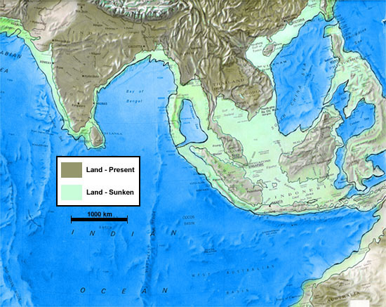
![]() However, anyone who inspects a chart of the oceanic bottoms in the region of Indonesia such as the Ice Age Map of Indonesia shown in Fig. 1 below, will readily concede that the South China Sea encircled by Indonesia indeed formed a continent during the last glaciation, which ended some 11,600 years ago. This chart clearly shows the sunken continent of Lemurian Atlantis in Indonesia, as well as the extensive sunken strip of Indian Atlantis at the Indus Delta.
However, anyone who inspects a chart of the oceanic bottoms in the region of Indonesia such as the Ice Age Map of Indonesia shown in Fig. 1 below, will readily concede that the South China Sea encircled by Indonesia indeed formed a continent during the last glaciation, which ended some 11,600 years ago. This chart clearly shows the sunken continent of Lemurian Atlantis in Indonesia, as well as the extensive sunken strip of Indian Atlantis at the Indus Delta.
![]() The map leaves no room for doubt about the reality of what we are affirming concerning Lemurian and Indian Atlantis, one almost wholly sunken, and the other sunken to a very considerable extension. We remark that this map in contrast to most others presenting proposed sites for Atlantis and/or Lemuria is purely scientific, rather than an invention of ours or of others. It is based on the detailed geophysical reconstruction of the seabottoms in the region in question, and portrays the areas of depth under 100 meters, which were obviously exposed during the Ice Age, when sea level dropped by that amount and even more.
The map leaves no room for doubt about the reality of what we are affirming concerning Lemurian and Indian Atlantis, one almost wholly sunken, and the other sunken to a very considerable extension. We remark that this map in contrast to most others presenting proposed sites for Atlantis and/or Lemuria is purely scientific, rather than an invention of ours or of others. It is based on the detailed geophysical reconstruction of the seabottoms in the region in question, and portrays the areas of depth under 100 meters, which were obviously exposed during the Ice Age, when sea level dropped by that amount and even more.
![]() In fact, several strictly scientific, similar maps exist, and can be seen elsewhere, inclusive in the Internet. One of these maps, was published in the National Geographic Magazine (vol.174, no.4, Oct. 1988, pg. 446-7) and is reproduced, for comparison, in Fig. 2 below. It shows the world as it was some 18,000 years ago, at the peak of the last glaciation of the Pleistocene Ice Age. As can be seen, this map corresponds quite closely with ours, shown in Fig. 1.
In fact, several strictly scientific, similar maps exist, and can be seen elsewhere, inclusive in the Internet. One of these maps, was published in the National Geographic Magazine (vol.174, no.4, Oct. 1988, pg. 446-7) and is reproduced, for comparison, in Fig. 2 below. It shows the world as it was some 18,000 years ago, at the peak of the last glaciation of the Pleistocene Ice Age. As can be seen, this map corresponds quite closely with ours, shown in Fig. 1.
![]()
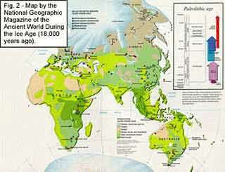 In particular, please note the huge chunk of land, of continental dimensions, to the south of Southeast Asia, and which became sunken when sea level rose, at the end of the Pleistocene. Another sizable piece of land in the Indus Delta, the site of the second Atlantis, also disappeared likewise, at that occasion. No other regions of the world display a similar event, including the Americas (not shown). The conclusion is that Atlantis, if Plato was in fact speaking truthfully, could only have been located in that region of the world.
![]()
As both maps above show, a huge extension of continental size prolonged Southeast Asia all the way down to Australia. This continental-sized land was indeed "larger than Asia [Minor] and Lybia [North Africa] put together", exactly as Plato affirms. It is seen to have been about two or three times larger than continental-sized India. It was also far larger than Australia, shown exagerated due to the peculiarities of the projection utilized.
The Lost Continent Finally Found, released on August 2005, is Prof. Arysio Santos' latest work.

![]() The Indonesian Islands and the Malay Peninsula that we nowadays observe are the unsunken relicts of Lemurian Atlantis, the lofty volcanic mountains that became the volcanic islands of this region, the true site of Paradise in all ancient traditions. The sunken portion of continental extension now forms the muddy, shallow bottoms of the South China Sea.
The Indonesian Islands and the Malay Peninsula that we nowadays observe are the unsunken relicts of Lemurian Atlantis, the lofty volcanic mountains that became the volcanic islands of this region, the true site of Paradise in all ancient traditions. The sunken portion of continental extension now forms the muddy, shallow bottoms of the South China Sea.
The South China Sea north of Indonesia and Java Sea have been advocated as a site for Atlantis. Key to this argument that Sundaland was the location of Atlantis is that the Ocean of Atlantis refers to the ocean which encircles Eurasia and Africa, which was the historical understanding until the time of Christopher Columbus. Proponents of this idea claim that natives of Sundaland who fled the rising waters or volcanic explosions eventually had contact with Ancient Egyptians, who later passed the story onto Plato who gets some but not all of the details correct, including location and time period. The main advocate of this theory is the Brazilian professor of nuclear physics Arysio Nunes dos Santos.
During the Last Glacial Maximum, what is now known as the Sunda Shelf was the location of a large subaerial coastal plain that was part of Sundaland. During the Last Glacial Maximum, Sundaland extended northward from Indonesia to Borneo and northwestward to the coast of Southeast Asia. Sundaland is quite tectonically stable lacking any known prehistory of any significant, much less cataclysmic, tectonic subsidence. Numerous studies by petroleum and Quaternary geologists have found a complete lack of any evidence for any Neogene and Quaternary volcanic activity within the Sunda Shelf despite its proximity to Indonesia.
Detailed studies[100][101] of late glacial and postglacial sea level rise for this part of the Sunda Shelf demonstrates that the first significant submergence of Sundaland by rising sea level occurred between 14,000 and 15,000 years ago. Periods of abrupt rise in sea level submerged a significant part of Sundaland beneath the South China Sea between 13,000 and 14,000 years ago. Between 14,300 and 14,600 years ago, a period of 300 years, sea level rose 16m (62 feet). Between 12,000 and 13,000 years ago, the submergence of Sundaland by rising sea level was relatively minor. A final period of rapid flooding of Sundaland by the South China Sea occurred between 11,000 to 12,000 years ago. The submergence of Sundaland during this period was minor in extent relative to the area submerged between 13,000 and 14,000 years ago. Evidence for any significant or cataclysmic submergence of Sundaland as the result of tectonic processes is completely lacking.Source:
- http://www.atlan.org/
- http://www.lost-civilizations.net/
- http://en.wikipedia.org/wiki/Location_hypotheses_of_Atlantis
Subscribe to:
Posts (Atom)